$\frac{1}{2}$
Survey of the Seti Gorge, the Himalayas
Cat: SCI
Pub: 2025
#2502
Harutaka Sakai (酒井治孝) et. al.
25114u
Title
Survey of the Seti Gorge, the Himalaya
ヒマラヤ山脈 Seti Gorgeの探査
Index
Tag
; ;
Key concept
Remarks
>Top 0. Introduction:
- In 2023 NHK broadcasted two Japanese canyonists ventured to the bottom of the Seti Gorge, the Himaraya, called 'the Devil Gorge' 'for the first time.
- Source: ResearchGate
0. 序文:
- 2023 NHKは、二人の峡谷探検家(田中彰&大西良治)によるヒマラヤ Seti Gorge (悪魔の谷) の世界初の谷底探査を放映した。

https://www.researchgate.net/figure/Geological-map-of-the-Seti-River-Basin-SRB-Central-Himalaya-Nepal-Mz-It-belongs-to_fig3_354660180
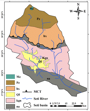
>Top 1. (Re:) Geological map of the Seti River Basin (SRB):
- Layers of strata:https://www.researchgate.net/figure/Geological-map-of-the-Seti-River-Basin-SRB-Central-Himalaya-Nepal-Mz-It-belongs-to_fig3_354660180
- Mz: Tibetan sedimentary: early Cretaceous, sandstone, shale, glauconite with ammonites and belemnites.
- Pz: Cambrian & Permian; limestone, sandstone, and shale with many fossils
- hx: Precamprian: gneisses, quartzites, and marbles.
- Ql: Paleistocene to Quarternary: Fluvial gracial gravels, conglomerates, and lacustrine clay with vertebrate fossils
- kgn: Precambrian to Paleozoic: augen gneisses and two mica granites (Kunch Grop and Nuwakot Group)
- na: Precmbraian to Lower Paleozoic: phyllites, sandstone, stromatolite, limestone, quartzite, and black slates along dykes and sills.
- MCT: Main Central Thrust, separate Lesser Himalaya with Higher Himalaya.
1. Seti River盆地の地質図 (参考):
- 地層:
- Mz: 初期白亜紀(チベット堆積岩):
砂岩・頁岩・海緑岩 (アンモナイト、矢石の化石を伴う)
- Pz: カンブリア紀・二畳紀:
石灰岩・砂岩・頁岩 (多くの化石)
- hx: 先カンブリア紀:
片麻岩・珪岩・大理石
- Ql: 第三紀更新性〜第四紀:
氷河堆積物・礫岩・湖成年度( 脊椎動物の化石を伴う)
- kgn: 先カンブリア紀〜古生代: 眼球片麻岩・花崗岩
- na: 先カンブリア紀〜下部古生代:
千枚岩・砂岩・ストロマトライト・石灰岩・珪岩・粘板岩(黒色で岩脈・貫入岩に沿う)
- MCT: 下部ヒマラヤと上部ヒマラヤの岩相境界
https://www.youtube.com/watch?v=wVnUJ2UlF9A (Following photo clips from NHK Special Program)
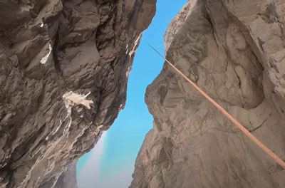
>Top 2. Canyoning to the Seti Gorge:
- 2020/11: Japanese Public Broadcasting NHK research team attempted the world-first research of the Seti Gorge, descending unexplored the bottom geology of the gorge.
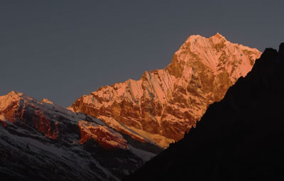
- It is a narrow gorge along the Seti River at the foot of Annapurna Mountains (>fig.), which is located at the central part of the Himalayans range spanning 2500km in five countries (Nepal, Bhutan, China, India, Pakistan). The survey is aimed to find how the 5km long and narrow gorge was formed; whose gaps are just a few meters apart at its narrowest , and is over 400m deep at the deepest, which is called 'the Devil’s Gorge'.
- Even when taking pictures from above with a drone, the bottom of the gorge is not visible. We could find a small flat area near the gorge and set up our basic survey camp.
- Once a French team made a geological map in the Himalaya area, but this particular gorge area remains unexplored and blank, because the gorge is too steep to confirm the geology there.
- The former theory of forming mechanism of the Seti Gorge was that a big glacial lake formed upstream of the Seti River about 20,000 year ago (end of Pleistocene), when moraine of the glacial deposits dammed the lake. But a huge earthquake caused the moraine layer to collapse, eroding the rock face and created the Seti Gorge.
- It will be the key to find a layered sedimentary rocks once deposited at the glacial lake.
- In 2022/11, two Japanese experts of the canyon explorers (canyonists) named Akira Tanaka and Ryoji Onishi were selected as the challenger of descending vertically using a single rope into this untrodden, steep-sided canyon.
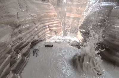
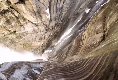
- During descenting by the rope, they discovered that the left side of the gorge was mainly calcarious rocks, while the rile side was mostly moraine deposits. Though it was off of the rainfall season, they could discover as many as 75 waterfalls with abundant water.
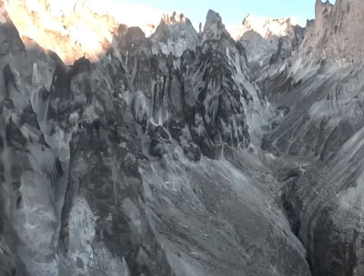
- On both sides of the upper area of the Seti Gorge, needle-like limestone mountains are lined up, blocking human access, as is called Devil's Gorge. The depth of the gorge is around 400m at the deepest, and rocks of the needed mountains are quite fragile, frequently falling rocks and breccia into the the gorge. The two canyonists could hardly trekked 3.5km along the bottom floor of the gorge.
2. Seti Gorgeへの峡谷降下:
- 2020/11: NHKの調査班は、それまで調査空白地帯であったSeti Gorge峡谷へ下降して谷底の調査するという世界初の試みに挑戦した。
- Seti Gorgeは、5カ国(ネパール・ブータン・中・印・パキスタン)に2400kmに亘ってまたがるヒマラヤ山脈の中央部になるアンナプルナ山脈の麓(>fig.)にあるSeti川沿いの狭い峡谷で、その成因を含めた地質調査を敢行。長さ約5kmの峡谷の間隔は狭い所は数mで、深さは最深部で400mを超えて '悪魔の谷'と呼ばれている。
- ドローンで上空から撮影しても、峡谷の底は見えない。峡谷の中腹にわずかな平地を見つけてキャンプを張った。
- かつてフランスの地質調査が行われたが、あまりにも険しい峡谷なので、その部分は未調査の空白地帯となっている。
- それまでは、約2万年前に氷河の堆積物モレーンがせき止めた氷河湖がSeti川上流にあったが、大地震によってモレーン層が決壊したことで岩肌が削られてSeti Gorgeが生成されたとの説であった。
- これを解明するには、氷河湖の堆積物だった層状の堆積岩を見つけることがその解明の鍵となる。
- 2022/11に日本の2名の峡谷探検家 (田中彰・大西良治Canyonist) が、この前人未到の絶壁の峡谷を降下して調査することになった。
- ロープで降下する途中で、峡谷左側は主に石灰岩、右側はモレーンの堆積物であることが判明。降雨量の少ない時期の調査だったが、水量豊富な滝が75ヶ所も発見できた。(>fig.)
- Seti Gorgeの上流側は、石灰質の針状の山々が連なる、正に'悪魔の谷'(>fig) で300m以上もある谷底のある場所では、針山からの落石(>fig)が頻繁にあり、極めて危険。二人は、谷底をなんとか3.5kmを踏破した。
>Top 3. Geological survey of the surrounding area:
- In 2023/3 Geologist Harutaka Sakai, Professor Emeritrus of Kyoto University also conducted a geological surve of the sounded areas.
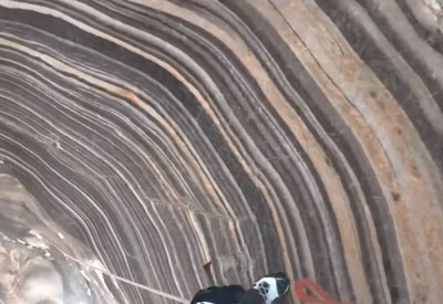
- The clearly layered sedimentary rocks of the Gorge (>ig.) are not the sedimentarh rocks derive a so-called galil lke, but rather was the old consoilidated marine sedimentary rock of the base of area formed around 500 million year ago (Cambrian period).
On the tope of it, there was probably a high mountain (of the same scale as Mt. Everest), and is believed to a recent
earthquake (almost M7-8) caused a sector collapse.
- This survey opened the door of uncovering a new hypothesis which an 'recent' big earthquake caused a landslide collapse in the upper part area of the Seti gorge, causing a huge amount of debris avalanche flowing toward Pokhara vilege (800m above sea level) located at the foot of the mountain. The amount of the avalanche is estimated to be about 22㎦, which can calculate the volume of another Mt. Everest (around 8800m), which added 4000m altitude above the ridgeline of 4800m.
- As one of the evidences for this hypothesis, we found the presence of dark cols between the ridges of the needle mountains, and also a large-scale of fault line near the boundary between the bedrock and the glacier.
- The reason of narrowness of the Seti Gorge (a few meters wide at its narrowest) can be explained due to the rapid erosion of the calcic rocks of both original base and cataclasite avalanche by an anual rainfall of 4,000mm (the rainy seasoen here is from May to Sept.)
3. 周辺の地質調査:
- 2023/3 酒井治孝京大名誉教授もこの地域の地質調査を実施した。
- Seti Gorgeの層状の堆積岩(>Fig.)は、想定していた氷河湖決壊の際の堆積岩ではなく、5億年前の古い固結した海成堆積岩(>fig)だった。その上部に、おそらく(エベレスト級の) 高い山が存在していて、大地震(M7-8級)によって山体崩壊(Sector collapse)を起こしたと見られる。
- 今回の調査判明した新説としては、大地震によってSeti Gorgeの上部で山体崩壊を起き、大量の岩屑雪崩 (Debris avalanche) が山麓のPokhara村(標高800m)方面へ流走した。その量は22㎦と見積もられている。この量から推定して、4800mの稜線の上にさらに4000mの第二のエベレストというべき山(8800m級)があり、それが山体崩壊を起こしたという説である。
- その一つの証拠としては、針山群の稜線の間に鞍部のコル(Col)認められること。また岩盤と氷河の境界付近に大規模な断層が見られること。
- Seti Gorgeが最も狭い場所で数mと狭いのも、この地域のモンスーン気候で年間4000mm (雨期は5-9月) 雨量が、石灰質の基盤に元からあった亀裂を覆った石灰質の破砕岩が、共に急速に侵食されて形成されたと言える。■
>Top 4. (Re:) Examples and Mechanism of the Sector Collapse:
- The recent examples of sector collapse were:
- On 1970/5/30 the Ancash earthquake (M7.7) occurred in Peru, which caused a sector collapse of Cascara North Peak (6655m), 15㎦ of avalanche hit the local village of Yungay at the speed of 300km/h; which became a major disaster of the most local 18,000 people were instantly buried.
- On 1980/5/18, 2.5㎦ of debris avalanche from St. Helena volcano in Washington, US, dropped from 2.6km hight and spread 29km away at the speed of over 100km/h in less than 10 minutes. A big creator (called Col) with an area of 6㎢ was formed at the source site.
- Debris avalanches run fast as high-velocity gas-solid fluidity phenomena, even which are not associated with an eruption of volcano.
- The debris avalanche deposits consist of large boulders and a granular matrix.
- The H/L ratio, where (H) is the maximum difference of height of the collapse volume, and (L) the maximum flowed distance. H/l will be the apparent friction coefficient. The average of H/L of non-volcanic landslides is an average of 0.27, while of volcanic one is an average of 0.12. Because the volcanic body is made of crushed pyroclastic rocks provide with energy from magma and hydrothermal explosion when it collapses. Also there is a volume effect; the H/L value decrease as the scale increases.
- The coefficient of kinetic friction of normal rocks is about 0.6 (angle of repose 30º), whereas that of debris avalanches is average 0.1 (gradient 6º), and for large-scale avalanches it is extremely low as less than 0.05 (gradient 3º or less).
- The flow process of debris avalanches consists of 1) collapse, 2) flow, and 3) deposition. It is important to elucidate these processes in view of the disaster prevention.
4. (参考): 山体崩壊の事例とそのメカニズム:
- 近年の山体崩壊の事例としては
- 1970/5/30にペルーでアンカシュ地震(M7.7)が発生し、ワスカラン北峰(6655m)で山体崩壊がを起きて、15 ㎦が300km/hでユンガイの集落を襲い、当時の人口18,000人のほとんどが死亡した大災害となった。
- 1980/5/18には米国ワシントン州のSt. Helens火山から2.5 ㎦の岩屑雪崩では、垂直落差2.6km、水平距離29kmを100km/h以上で10分足らずで流走した。給源には面積6㎢の馬蹄形クレータ (Col)が形成された。
- 岩屑雪崩は、噴火と関係しなくても、気-固系の高速流動現象となる。
- その堆積物は、大型の岩塊と粉粒体状の基質(debris avalanche matrix)から成る。
- 最大落差(H)と最大流送走距離(L)のH/L値が見かけ摩擦係数となる。非火山性は平均0.27に対し、火山性の場合のH/L値は平均0.12である。これは火山体が破砕された火砕物からなり、崩壊時のマグマや熱水爆発のエネルギーが与えられることによる。また規模の増大にともなってH/L値が低くなるボリューム効果も見られる。
- 普通の岩石の動摩擦係数は0.6程度 (安息角30º)に対し、岩屑雪崩は平均0.1 (傾斜 6º)、大規模なものは0.05以下(傾斜3º以下)と極めて低い。
- 岩屑雪崩の流走過程は、崩落・流走・堆積とあるが、この過程の解明は防災上重要である。
Re: Oshika museum of Japan Median Tectonic Line.: (https://mtl-muse.com/study/faultrocks/classification/)
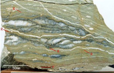
>Top 5. (Re:) Features of 'Cataclasite':
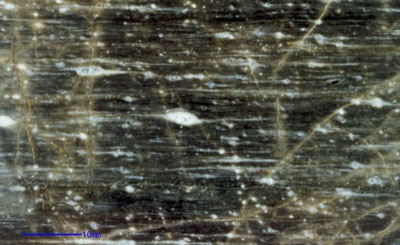
- Cataclasite refers to rocks that have been broken and deformed by fault movement. Because they form near the surface of the crust under lower temperature and pressure, which cause no recrystallization of minerals retaining characteristics of the original rock.
- Fault rocks are classified according to the presence or absence of crushing, fusion, and recrystallization, as well as whether they have foliated structures, and whether they are cohesive or incohesive. Ductile deformation is more common in deeper formation, while brittle fracture is more common in shallower one.
- In particular, Fault gouge (>fig.) is defined that contains less than 30% of fractured rock fragments percentage, is less than 10mm in grain size. Fault gouge is unconsolidated, and has a soft clay matrix that can be broken down by hand.
- While, Fault breccia is defined that contains more than 30% fractured rock fragments and is unconsolidated.
- Cataclasite is defined that has undergone brittle fracture at low temperature and high pressure depths (5-10km) and has a consolidated matrix.
- Mylonite is defined that have undergone plastic flow deep in the faults at high temperatures show fine-grained rocks that have been dynamically recrystallized from the parent rock minerals.
- The temperature conditions for mylonite deformation increase in the following order: calcite > quartz/mica > K-feldspar > plagioclase > amphibole > olivine > pyroxene.
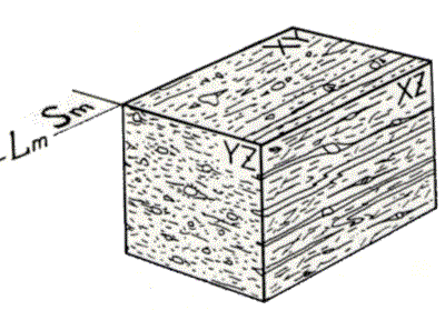
- In a mylonite whose parent rock is granite on the Ryoke belt along the Median Tectonic Line in Japan, quartz polycrystallizes, and biotite and feldspar form a fine-grained matrix. Amphibole, plagioclase, and K-feldspar, which do not easily polycrystallize, remain as porphyroclasts.
- Porphyroclasts often have a pressure shadow (>fig.) that looks like an elongated tail. This is because the presence of porphyroclasts creates areas of weak shear stress in a specific direction around them, where recrystallized minerals with large grain sizes form. For example, the constituent minerals of the pressure shadow of plagioclase porphyroclasts are K-feldspar and quartz, which serve as an indicator for determining the sense of shear (relative movement)(>fig.).
5. カタクラサイトの特徴 (参考):
- 断層運動によって岩石が破砕され変形した破砕岩 (cataclasite) をいう。温度圧力が低く、地表近辺で形成されるので、鉱物の再結晶がなく元の岩石の特徴を残している。
- 断層岩は、粉砕(Crushing)、融解(Fusion)、再結晶(Recrystalization)、また面構造(Foliated)の有無、さらには固結(cohesive)・非固結(incohesive)の状態により分類される。深部では延性変形、浅部では脆性破壊がより多い。
- 特に、破砕岩片の存在比が<30%で、その粒径が<10mmで非固結で、手で崩せるほど軟弱で粘土質の基質部の多いものを'断層ガウジ’(Fault gouge)という(>fig.)
- また、破砕岩片が>30%で非固結のものは'断層角礫(Fault breccia)'という。
- 低温高圧条件の深度(5-10km)で脆性破壊を生じて、基質が固結しているものをカタクラサイト(Cataclasite)と呼ぶ。
- 高温の断層深部で塑性流動を受けた断層岩は、原岩の鉱物の動的再結晶化による細粒化された岩石をマイロナイト(Mylonite)という。
- マイロナイトの変形の温度条件は方解石>石英・雲母>カリ長石>斜長石>角閃石>橄欖石>輝石の順に高くなる。
- 中央構造線の領家帯側の花崗岩を原岩とするマイロナイトでは、石英は多結晶化し、黒雲母や長石は細粒基質を構成する。多結晶化しにくい角閃石・斜長石・カリ長石はポーフィロクラスト(Porphyroclast)として残存する。
- ポーフィロクラストには尾を引き出したようなPressure shadow (>fig.) が発達することが多い。これはホーフィロクラスとの存在のためにその周囲が特定の方向に剪断応力の弱い部分が生じ、そこに粒径が大きい再結晶鉱物が形成される。例えば斜長石PorphyroclastのPressure shadowの構成鉱物はカリ長石と石英であり、剪断のセンス(sense; 相対的な動き)(>fig.)を判定する指標となる。
>Top 6. Comment:
6. コメント:
Comment
- Human life span is too short to observe the mountain building and mountain collapse which take long period of time. The orient proverb says, 'it is unchangeable like mountains.'
- But in geological time span, mountains are really changeable, which should be expressed as 'swiftly changed like water (=liquid)'. All high mountains such as Mt. Everest and Mt. Fuji will eventually collapse and become flat. In the meanwhile, new mountains will be formed; which will be another impressive landscapes. I hope that our long descendants who could see and enjoy the new scenery.
- 長い時間をかけて変動している造山運動や山体崩壊などに比べてあまりにも短い人間の寿命から見ると、正に'動かざること山の如し'である。
- 実際には、地質的には、山も'変動すること水(=液体)の如し'なのである。すべての高い山、エベレスト山も富士山も、いずれは崩壊して低くなる。それでもその間新たな山が形成され、感動する風景はまた現れるであろう。それを見る我々の末裔もその新しい景色を愛でることができることを祈りたい。
$\frac{1}{2}$ |
Survey of the Seti Gorge, the Himalayas
|
Cat: SCI |
Harutaka Sakai (酒井治孝) et. al. |
25114u |
Title |
Survey of the Seti Gorge, the Himalaya |
ヒマラヤ山脈 Seti Gorgeの探査 |
|---|---|---|
Index |
||
Tag |
; ; | |
Key concept |
Remarks |
|
>Top 0. Introduction:
|
0. 序文:
|
|
| https://www.researchgate.net/figure/Geological-map-of-the-Seti-River-Basin-SRB-Central-Himalaya-Nepal-Mz-It-belongs-to_fig3_354660180 | ||
>Top 1. (Re:) Geological map of the Seti River Basin (SRB):
|
1. Seti River盆地の地質図 (参考):
|
|
| https://www.youtube.com/watch?v=wVnUJ2UlF9A (Following photo clips from NHK Special Program) | ||
>Top 2. Canyoning to the Seti Gorge:
|
2. Seti Gorgeへの峡谷降下:
|
|
>Top 3. Geological survey of the surrounding area:
|
3. 周辺の地質調査:
|
|
>Top 4. (Re:) Examples and Mechanism of the Sector Collapse:
|
4. (参考): 山体崩壊の事例とそのメカニズム:
|
| Re: Oshika museum of Japan Median Tectonic Line.: (https://mtl-muse.com/study/faultrocks/classification/) | ||
>Top 5. (Re:) Features of 'Cataclasite':
|
5. カタクラサイトの特徴 (参考):
|
|
>Top 6. Comment: |
6. コメント: |
|
Comment |
|
|