>Top 2. Railway Construction across Afganistan:
https://www.youtube.com/watch?v=SlwQ6T46wT8
- Railway Blank Space:
Afghanistan shares a 76 km border with China. And there is not a single road, railway, or official trade crossing along any of it. Just mountains, ice, and a pass sitting at almost 5,000 m. Now, China wants to run a railway line right across that country. More than 2,100 km of track from Xīnjang to Iran, with nearly half of it crossing Afghan soil. Iran's tracks already reach the Afghan border in the west. Uzbekistan's tracks already cross in the north. China runs one of the biggest rail systems on the planet just to the east. And in the middle sits a huge empty gap, a country of 40 million people with no connected national railway at all. So why does Beijing want to spend billions closing a gap that Britain and Russia both failed to close 130 years ago? And can a railway really cross earthquake zones, collapsing valleys, and passes buried in snow half the year?
- Railway carries soldiers, etc.:
The answer starts with a decision made by Afghan rulers in the 1800s. A decision that still shapes every map drawn today. The country that turned down the tracks. In the 19th century, two empires laid rails straight toward Afghanistan and then stopped cold, because Afghan rulers told them no. The Russian Empire was pushing south through Central Asia. Britain controlled India next door. Both wanted steel tracks running through Afghan territory and both built lines right up to the frontier. Afghan leaders looked at those tracks and saw exactly what they were. A railway does not just carry wheat and cloth. It carries soldiers, artillery and supply trains, and it carries them fast. Kabul could be reached in days instead of months. So the answer was no. Not once, but again and again for decades. Afghan rulers refused to let foreign rails continue past the border. And that refusal worked. No army rolled in on a train.
- Continuous Wars in Afganistan:
But the cost showed up 100 years later. While railways spread across India, Iran, and Russian Central Asia, linking cities and ports and mines, Afghanistan entered the 20th century with almost nothing. The rest of Asia got a network. Afghanistan got a blank space. There were small attempts. In the 1920s, a short line ran a few kilometers outside Kabul. More of a novelty than a transport system. It did not last. Every later plan ran into the same three walls, money, mountains, and politics. And then came 1979 when Soviet forces entered the country. What followed was civil war, Taliban rule, and the American-led war after 2001. More than 40 years of conflict. During all of that, no government had the luxury of planning a 1,000 km railway. They patched roads. They kept the highway between Kabul and Kandahar open. They repaired bridges that got blown up. Long-term infrastructure needs 20 years of stability. And Afghanistan almost never got five.
- Missing Hallway:
Here is what makes today's situation strange. Afghanistan does have railway tracks now. Uzbekistan built a line down to Mazar-i-Sharif through the border town of Hairaton. Turkmenistan opened a connection in the northwest. Iran built tracks toward Herat from the west. So trains do enter the country, but every one of those lines is a doorway, not a hallway. They come a short distance in from a border and simply stop. None of them meet each other. You cannot put cargo on a train in Harat and ride it to Mazar-i-Sharif because the track between those cities does not exist. That means almost everything still moves by truck. Fuel, flour, cement, machinery, all of it grinding over mountain roads and through crossings that can shut down without warning. Now the missing hallway is the whole problem. And the reason nobody has built it yet is not only war. It is the ground itself. The Hindu Kush does not negotiate. The Hindu Kush cuts Afghanistan almost in half with peaks above 7,000 m and valleys. so narrow that a road and a river have to share the same floor.
- Reailway requires flat land:
Railways hate this kind of land. A train cannot climb a steep slope the way a truck can. Steel wheels on steel rails have very little grip. So, a railway needs gentle grades, wide curves, and long straight runs. In a country shaped like a crumpled sheet of paper, those things do not exist naturally. You have to manufacture them and you manufacture them with tunnels and bridges. That is where the money disappears. A kilometer of flat desert railway is cheap. A kilometer of tunnel through fractured mountain rock can cost 20 or 30 times more. And the rock in Afghanistan is not friendly. The country sits on one of the most active earthquake zones in the world where the Indian plate grinds north into Asia. Northeastern Afghanistan, especially the Badakhshan region, gets shaken constantly. Quakes above magnitude 6 happen regularly. A tunnel board through ground that is still moving needs heavier lining, more reinforcement, and constant inspection for the rest of its life. Then add water. Spring snow melt turns quiet streams into brown torrents that tear out river banks. Landslides bury roads every single year. Winter dumps enough snow on the high passes to close them for months. The Salang Pass, the main road link between northern and southern Afghanistan, shuts down regularly from avalanches. And that is a tunnel that has existed since 1964.
- Merit of Railway Network:
Now imagine keeping a railway open through country like that, where one washed out embankment stops every train on the line. There is one more geographic fact that shapes everything and it is easy to miss on a map. Afghanistan has no coastline, not one meter of it. Most countries build railways to reach a port because a port is where cargo becomes cheap. Afghanistan cannot do that. Any railway built inside its borders only has value if it connects to somebody else's network in Iran or Pakistan or Uzbekistan or China. That single fact makes the whole project political by nature. Afghanistan cannot build a useful railway alone and no neighbor will build one unless the trains keep moving on the other side of every border. So why would anyone take this on? Because the country that has most seriously considered it has already done harder things.
- Five Nations Railway Corridor:
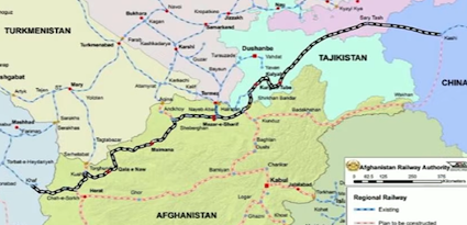
Chinese engineers ran a railway across the Tibetan plateau over permanently frozen ground with tracks passing above 5,000 m and oxygen pumped into the passenger cars. They laid lines through the shifting sands of the Taklamakan desert. They built the Duge Bridge in Guizhou with a deck 565 m above the river below. If any country has a track record of turning impossible terrain into a working line, it is China. And that experience is exactly why in 2014, five governments sat down in a room and signed their names to a plan, a signature in Duchobe. In December 2014, representatives from China, Kyrgystan, Tajikistan, Afghanistan, and Iran met in Dushanbe, the capital of Tajikistan, and agreed to study something called the Five Nations Railway Corridor. On paper, it was elegant. Tracks would start in China's Xinjiang region, cross Kyrgyzstan and Tajikistan, drop into northern Afghanistan, run west across several Afghan provinces, and link up with Iran's network near Harat. From there, cargo could keep rolling to Tehran, Turkey, or the Persian Gulf, one continuous ride from Western China to the Middle East. The timing was not a coincidence.
- China's Belt and Road Initiative (2013):
China had launched the Belt and Road Initiative the year before in 2013, pouring money into ports, highways, and rail corridors across Asia. Beijing wanted land routes to Central Asia, the Middle East, and Europe that did not depend on a single choke point. Afghanistan sat right next to several of those planned corridors, and yet it was left out of nearly all the early projects for the simple reason that there was nothing to plug into*7. You cannot add a country to a rail network when the country has no network. The early price tag was more than USD2 billion. That number is worth pausing on, because it was an estimate made before detailed route surveys, before geological drilling, and before years of inflation in steel, cement, and labor. Engineers who have looked at the terrain since then talk about figures several times higher. Tunnels and earthquake proofing do not get cheaper when you actually measure the mountain. And the 2014 agreement was a study agreement, not a construction contract. Nobody had finished a final design. Nobody had locked in the full financing. Nobody had answered the hardest question of all, which was how thousands of workers and hundreds of kilometers of exposed track would be protected in a country still at war. So the main Afghan section never started. The paper stayed paper.
- Taliban Government established (2021):
Then August 2021 changed the board completely. The Taliban returned to power. Western development money mostly vanished and a lot of foreign engineers went home. But the neighbors did not walk away. China, Iran, Uzbekistan and others kept talking to the new authorities because geography does not care who is in charge. In 2023, Afghanistan formally joined China's Belt and Road cooperation framework, which put the corridor back in official documents rather than just in conversations. Iran then pushed something bolder. Instead of detouring north through Tajikistan and Kyrgyzstan, why not keep the whole line inside Afghanistan? A railway from Herat to Mazar-i-Sharif, then east through Badakhshan, then out through the narrow Wakhan corridor straight into China. Fewer borders, fewer governments to satisfy, fewer customs stops. On a map, it looks obviously better. But that proposal swaps one kind of nightmare for another. It removes the political tangle of crossing two extra countries and replaces it with the single most brutal piece of engineering on the entire route.
- Herat - a key railway terminal?:
To understand why, you have to look at what already exists in the west and then at what weights in the east. The western half is already half-built. Iran's railway network already reaches Khaf, a town sitting right at the Afghan border and tracks already cross over near Ghorian heading toward Herat. That is the good news and it is bigger news than it sounds. The hardest part of any long corridor is usually the first and last connection to an existing system, and in the west that connection is largely done. Herat is the natural western gateway. It is one of Afghanistan's largest cities with well over half a million people sitting close to both Iran and Turkmenistan on relatively flat ground compared to the rest of the country. A container loaded in Herat could reach Iran's national network, then continue to Tehran or north into Turkey or south to Bandar-Abbas on the Persian Gulf, which is Iran's biggest container port. In other words, Herat is already one train ride from the ocean. The rest of Afghanistan is not. The missing piece starts immediately east of Herat. This is the long central line running across northern Afghanistan through provinces that grow wheat, cotton, grapes, pomegranates, and almonds, and that currently move every bit of it by truck. Those farm regions have a real problem with distance. Fresh fruit loses value every hour it spends on a road, and Afghan pomegranates and raisins compete in markets thousands of kilometers away.
- Afganistan will be the Cross-railwayroad:
A railway does not just cut cost, it cuts spoilage*腐敗. The true center of the whole plan is Mazzar-i-Sharif. This city already has rails thanks to the Uzbeck built line coming down from Hairatan. Add ab east-to-west line through it, and Mazzar-i-Sharif stops being a dead end and becomes a junction. Cargo arriving from China or Central Asia could turn left and head for Iran. Trains coming up from Iran could turn right and head for Uzbekiststan and the rest of Central Asia. One city, four directions, and suddenly a country that used to be a barrier becomes a crossroads. That is the peace Afghanistan has genuinely never had. Not a border connection, but a backbone, a single spine that links the north and the west to several international markets at once. Roads cannot do that job at the same scale. A single freight train can carry what dozens of trucks carry using less fuel with fewer drivers and without pounding a mountain highway to gravel. From Mazar-i-Sharif though planners face a fork and the two options could not be more different.
- The Wakhan Route:
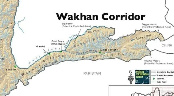
The original five nations route swings north out of Afghanistan into Tajikhstan, crosses Kyrgystan, and enters China near Kashgar. It means more border posts and more governments, but it dodges Afghanistan's worst mountains. The other option stays inside Afghanistan the whole way, pushing east through Kunduz, Takhar, and Badakhshan toward that narrow finger of land in the far northeast. That finger is the Wakhan corridor and what waits at the end of it is the reason this railway gets called impossible. The Wakhan problem. The Wakhan corridor is a strip of Afghan land roughly 350 km long and in places only 15 km wide squeezed between Tajikistan and Pakistan. And it ends at a 76 kilometer border with China where nothing crosses, no highway, no railway, no customs post. The boundary was drawn in the 1890s specifically so Russian and British territory would not touch and the result is a corridor that exists mainly as a buffer. The only natural way through to China is the Walkj Chira Pass, sitting at close to 5,000 m, more than 16,000 ft. For comparison, that is higher than any point in the Alps. The pass is a rough track used by a handful of traders and herders with pack animals, and it is buried in snow for much of the year. The two countries do not even run a formal crossing there, and the time zones on either side jump by 3 and 1/2 hours. Now, think about what a railway would need in that place. Not a foot path, but a graded line with tunnels long enough to get under the ridge, avalanche shelters, snow fences, permanent maintenance crews, and supply roads built first just to deliver the equipment. There are barely any villages for hundreds of kilometers. Workers would need camps, water, fuel, medical support, and oxygen at altitude. Every sack of cement would have to be trucked in over the same terrible ground the railway is meant to replace. This is why a route that looks 500 km shorter on a map can end up costing far more than the longer one that swings through two extra countries.
- Railway Gauge Problem:
And even after you conquer the mountain, there is a quieter problem that could bite just as hard. Track gauge. That is simply the distance between the two rails, and the world never agreed on one number. China and Iran both use 1,435 mm standard gauge. Uzbekistan, Tajikhistan, and most of the former Soviet system use a wider, 1,520 millimeter gauge. A train built for one cannot roll onto the other. Afghanistan, having received its tracks as gifts from different neighbors, ended up with different gauges depending on who built which piece. So, the governments involved have three choices, and none of them are free. Pick a single gauge for the whole corridor, which means somebody's existing line becomes the odd one out. Lay a third rail so both kinds of trains can use the same track which is expensive and complicated at every switch or build transfer terminals where cranes lift every container from one train to another. That last option is the common solution and it works but each transfer adds hours and cost. When you are competing with ships hours matter. Stack all of it together and you get a fair question. Why would anyone pour billions into a line this hard across a country with no port when Chinese freight trains already reach Iran through Kazakhstan and Turkmenistan? The answer is partly about routes, but mostly it is about what is sitting under the Afghan ground.
- The trillion dollar argument:
Afghanistan is sitting on mineral deposits that government surveys have valued somewhere between1 trillion and 3 trillion dollars and almost none of it has been dug up. Copper, iron ore, coal, gold, chromite, rare earth elements, lithium bearing rock. The country is in geological terms absurdly rich and almost completely undeveloped. And the reason is simple. Heavy rock is the worst possible cargo mess for a truck. Take Mes Aynak, southeast of Kabul. It holds one of the largest undeveloped copper deposits anywhere on Earth. Back in 2007, a Chinese consortium led by the Metallurgical Corporation of China won the contract to develop it and the original plan included the mine, processing plants, a power station, and a railway link. Then came delay after delay, security worries. A remarkable ancient Buddhist city discovered right on top of the or body with monasteries and statues that archaeologists needed years to document, arguments over contract terms, and missing infrastructure because a copper mine without a railway is a very expensive hole.
- Hajigok Iron Ore:
Then there is Hajigok, west of Kabul with estimates of around 1.8 billion tons of iron ore. Try moving that by road. A truck might carry 30 tons on a good day over mountain switchbacks burning imported diesel with drivers tolls and breakdowns. A single freight train can haul thousands of tons in one movement. The cost per ton is not slightly better. It is a completely different category for copper concentrate, coal, stone, and iron. Rail is not a convenience. It is the only way exports make financial sense at all. That is the shape of the deal China is looking at. Send mining machinery, vehicles, drilling equipment, and industrial goods west into Afghanistan on loaded trains. Fill those same trains with ore and concentrate on the way back to processing plants in China. Empty trains are wasted money and this route promises cargo in both directions which is exactly what makes a railway profitable. There is a second reason and it has nothing to do with rocks. Options. Most of China's overland trade with Europe and Western Asia squeezes through a small number of corridors. Some run through Russia, some cross Kazakhstan, some loop around the Caspian Sea. Beijing is also helping build the China to Kyrgyzstan to Uzbekiststan railway, which opens another path. But every one of those routes can be interrupted by sanctions, disputes, or a closed border.
- Wakhan Corridor:
A corridor through Afghanistan would give Western China a shorter, more direct link to Iran. And from Iran onward to Turkey, the Gulf, and Indian Ocean ports. In shipping having a spare route is worth real money, even in the years you never use it. And for Afghanistan, the prize is the thing it has been missing since those 19th century refusals. Not a foreign army on rails, but a spine of its own, linking farms and cities in the north and west to markets in four directions. The catch is that the line has to serve Afghan industry too and not just carry finished goods in one direction and raw ore out the other. For now, no final route has full approval. The alignment still depends on drilling results, real cost numbers, security guarantees, and which governments are willing to sign the checks. What is certain is that the Afghan section is the biggest missing piece and whether the whole corridor lives or dies will be decided inside those mountains. In short, the western tracks already exist. The eastern mountains are brutal and a trillion dollars in minerals is the reason anyone keeps drawing the map.
|
2. アフガニスタン経由鉄道建設:
- 鉄道空白地帯アフガニスタン:
アフガニスタンは中国と76kmにわたって国境を接している。しかし、その境界線沿いには、道路も鉄道も、公式な貿易のための検問所も一つとして存在しない。あるのは山と氷、そして標高5000m近くに位置する峠だけだ。今、中国はこの国を横断する鉄道の敷設を計画している。新疆からイランに至る2100kmを超える路線であり、その半分近くがアフガニスタンの領土を通ることになる。西側ではイランの鉄道網がすでにアフガニスタン国境まで達しており、北側ではウズベキスタンの鉄道網が国境を越えている。東側には、世界最大級の鉄道網を持つ中国が控えている。その真ん中に、4000万人の人口を抱えながら、国内鉄道網が全く存在しない巨大な空白地帯が広がっている。では、なぜ中国政府は、130年前にイギリスとロシアが挑んで失敗したこの空白を埋めるために、巨額の資金を投じようとしているのだろうか。そもそも、地震帯や崩落の危険がある谷、そして一年の半分は雪に閉ざされる峠を、鉄道が越えることなど本当に可能なのだろうか。
- 鉄道は兵士を運ぶ:
その答えは、19Cのアフガニスタンの支配者たちが下したある決断に遡る。その決断は、今日描かれるあらゆる地図のあり方に、今なお影響を与え続けている。鉄道の敷設を拒んだ国、19C、二つの帝国がアフガニスタンに向けて鉄道を敷こうとしたが、アフガニスタンの支配者たちがノーと突きつけたことで、その計画は完全に頓挫した。当時、ロシア帝国は中央アジアを南下し、イギリスは隣国インドを支配下に置いていた。両国ともアフガニスタンの領土内に鉄道を通すことを望み、国境のすぐそばまで線路を敷いた。しかし、アフガニスタンの指導者たちは、鉄道の真の正体を見抜いていた。鉄道は単に小麦や布を運ぶだけのものではない。兵士や大砲、補給物資を、それも極めて迅速に運ぶ手段となり得るのだ。鉄道があれば、数ヶ月かかっていたKabulまでの道のりが、わずか数日で到達可能になってしまう。だからこそ、答えはノーだった。一度だけではない。何十年もの間、繰り返しノーと言い続けたのだ。アフガニスタンの支配者たちは、外国の鉄道が国境を越えて国内に入ってくることを拒絶した。そして、その拒絶は功を奏した。鉄道に乗って軍隊が侵攻してくることはなかったのである。
- 引き続く戦乱の歴史:
しかし、その代償は100年後に明らかとなった。インド、イラン、ロシア領中央アジアに鉄道網が広がり、都市や港、鉱山が結ばれていく一方で、アフガニスタンはほとんど何もない状態で20Cを迎えた。アジアの他の地域が鉄道網を手に入れたのに対し、アフガニスタンには空白が残されたのである。小規模な試みはあった。1920年代には、Kabul郊外に数kmの短い路線が敷かれたが、それは輸送システムというよりは、むしろ目新しい見世物のようなものに過ぎず、長くは続かなかった。その後の計画もすべて、資金・山岳地帯・政治という3つの壁に阻まれてきた。そして1979年、ソ連軍が侵攻。その後は内戦、タリバンによる統治、そして2001年以降の米国主導の戦争と、40年以上にわたる紛争が続いた。この間、どの政権にも1000kmに及ぶ鉄道を計画する余裕などなかった。彼らが行えたのは、道路の応急処置や、KabulとKandaharを結ぶ幹線道路の維持、そして爆破された橋の修復といったことだけだった。長期的なインフラ整備には20年程度の安定が必要だが、アフガニスタンには5年間の安定すら、ほとんど訪れることがなかったのだ。
- つながらない鉄道網:
現在の状況が奇妙なのは、アフガニスタンに今、鉄道の線路が存在しているという点である。ウズベキスタンは国境の町Hairatonを経由してMazar-i-Sharifまで路線を敷き、トルクメニスタンは北西部に接続路線を開通させた。イランも西側からHeratに向けて線路を建設した。つまり、列車は確かに国内に入ってきているのだが、それらの路線はすべて入口であって、通路にはなっていない。国境から少し入ったところで、ただ止まってしまうだけなのだ。路線同士はどこもつながっていない。例えば、Hertで列車に貨物を積み込み、そのままMazar-i-Sharifまで運ぶことはできない。その間を結ぶ線路が存在しないからだ。そのため、燃料、小麦粉、セメント、機械類といったあらゆる物資は、依然としてトラックで運ばれている。それらは山道を進み、いつ閉鎖されるかわからないような場所を通り抜けていくしかない。さて、このつながっていない通路こそが、最大の問題なのである。まだ誰もそれを建設できていない理由は、単に戦争のせいだけではない。大地そのものに原因があるのだ。Hindu Kush山脈は、妥協を許さない。標高7000mを超える峰々がアフガニスタンをほぼ真っ二つに分断し、谷はあまりに狭く、道路と川が同じ空間を共有せざるを得ないほどなのである。
- 鉄道には平坦な土地が必要:
鉄道にとって、こうした地形は厄介なものだ。トラックとは異なり、列車は急勾配を登ることができない。鉄の車輪と鉄のレールでは、摩擦力が非常に小さいからだ。そのため、鉄道には緩やかな勾配、大きなカーブ、そして長い直線区間が必要となる。くしゃくしゃに丸めた紙のような地形の国には、そうした条件は自然には存在しない。トンネルや橋を建設して、人工的に作り出すしかないのだ。そこに莫大な費用が消えていく。平坦な砂漠に鉄道を敷く場合、1kmあたりのコストは安く済む。一方、崩れやすい岩盤の山を貫くトンネルでは、その20-30倍もの費用がかかることもある。しかも、アフガニスタンの岩盤は非常に厄介だ。この国は、インドプレートがアジアプレートに向かって北進し、激しく衝突する、世界有数の地震帯に位置している。アフガニスタン北東部、特にBadakhshan地方は絶えず揺れに見舞われており、マグニチュード6を超える地震も頻繁に発生する。地殻変動が続く土地にトンネルを掘るには、より強固な内壁や補強が必要であり、完成後も永続的に点検を続けなければならない。さらに、水の問題もある。春には雪解け水が静かな川を濁流へと変え、川岸を削り取ってしまう。毎年必ずと言っていいほど土砂崩れが発生し、道路が埋もれる。冬には高所の峠に大量の雪が降り積もり、数ヶ月にわたって通行不能になることもある。アフガニスタン北部と南部を結ぶ主要ルートであるSalang峠も、雪崩によって頻繁に閉鎖される。ちなみに、この峠にあるトンネルは1964年から存在するものである。
- 鉄道網の価値:
このような過酷な環境下で、鉄道網を維持することを想像してみてほしい。路盤が一度でも崩壊すれば、路線上のすべての列車がストップしてしまうのだ。もう一つ、すべてを左右する地理的な事実がある。地図を見ていると見落としがちだが、アフガニスタンには海岸線が一切ない。多くの国は港を目指して鉄道を敷く。港があれば、貨物の輸送コストを大幅に下げられるからだ。しかし、アフガニスタンにはそれができない。国内に鉄道を敷いたとしても、イラン、パキスタン、ウズベキスタン、あるいは中国といった近隣諸国の鉄道網と接続して初めて価値が生まれる。この事実こそが、鉄道建設プロジェクトを本質的に政治的なものにしている。アフガニスタン単独では有用な鉄道を建設することはできず、かといって近隣諸国も、国境の向こう側で列車が確実に運行され続けなければ、鉄道を建設しようとはしないだろう。では、なぜ誰がこのような困難な事業を引き受けようとするのだろうか。なぜなら、それを最も真剣に検討してきた国は、すでにそれよりも困難なことを成し遂げているからだ。
- 5カ国鉄道回廊構想:
中国の技術者たちは、チベット高原の永久凍土の上に鉄道を敷設した。線路は標高5000mを超える地点を通過し、客車内には酸素が供給される仕組みになっている。彼らはTaklamakan砂漠の流動する砂地にも線路を通した。また、貴州省には、川面から565mの高さに橋桁を持つ都格 (Duge)大橋を建設した。困難な地形を克服し、実際に機能する鉄道路線へと変えてきた実績を持つ国があるとすれば、それは中国をおいて他にない。こうした経験があったからこそ、2014年、5カ国の政府関係者が一堂に会し、ある計画に署名することになったのである。2014年12月、中国、キルギス、タジキスタン、アフガニスタン、イランの代表者がタジキスタンの首都Dushanbeに集まり、5カ国鉄道回廊 (Five Nations Railway Corridor) と呼ばれる構想の検討に合意した。計画書の上では、それは見事なものだった。中国の新疆ウイグル自治区を起点とし、キルギスとタジキスタンを横断してアフガニスタン北部に入り、同国北部のいくつかの州を西へと抜けて、Herat近郊でイランの鉄道網と接続するというものだ。そこから貨物はTehran、トルコ、あるいはペルシャ湾へと輸送され、中国西部から中東までが一本の鉄路で結ばれることになる。このタイミングは、決して偶然ではない。
- 中国の一帯一路構想 (2013):
中国は前年の2013年に一帯一路構想を打ち出し、アジア全域の港湾、高速道路、鉄道回廊に巨額の資金を投じていた。中国政府は、特定のチョークポイントに依存することのない、中央アジア、中東、そして欧州へと続く陸路を求めていたのである。アフガニスタンは、計画されていたそれらの回廊のすぐ隣に位置していたにもかかわらず、初期のプロジェクトのほとんどから除外されていた。その理由は単純で、接続すべきインフラが同国には存在しなかったからだ。鉄道網を持たない国を、既存の鉄道ネットワークに組み込むことはできない。当初の推定建設費は20億米ドルを超えていた。この数字には注目しておく必要がある。なぜなら、これは詳細なルート調査や地質調査が行われる前、さらには鉄鋼、セメント、人件費の長年にわたるインフレが起こる前の見積もりだったからだ。その後、現地の地形を調査した技術者たちは、実際にはその数倍の費用がかかると指摘している。実際に山を測量してみれば、トンネル掘削や耐震対策の費用が安くなることはない。2014年の合意はあくまで調査に関するものであり、建設契約ではなかった。最終設計が完了していたわけでも、必要な資金の全額が確保されていたわけでもない。それどころか、最も困難な問い、戦争状態が続く国において、数千人の作業員と数百kmルに及ぶむき出しの線路をどう守るのかに対する答えも、誰一人として出せていなかった。こうして、アフガニスタン国内の主要区間は、ついに着工されることはなかった。計画は、あくまで紙の上のものにとどまったのである。
- タリバン政権樹立 (2021):
2021/8、状況は一変した。タリバンが権力の座に復帰したのである。西側諸国からの開発資金はほとんど消え、多くの外国人技術者も帰国した。しかし、近隣諸国は手を引かなかった。中国、イラン、ウズベキスタンなどは、新たな統治者たちとの対話を継続した。誰が権力を握っていようと、地理的条件は変わらないからである。2023年、アフガニスタンは中国の一帯一路協力枠組みに正式に参加した。これにより、この回廊は単なる議論の対象から、公式文書に記載されるものへと格上げされた。その後、イランはさらに大胆な案を提示した。タジキスタンやキルギスを経由する北回りのルートではなく、全区間をアフガニスタン国内に収めてはどうか、というものだ。HeratからMazar-i-Sharifへ至り、そこから東へ向かってBadakhshan州を通り、細長いWakhan回廊を抜けて中国へ直接つなぐという構想である。国境を越える回数は減り、調整すべき政府の数も少なくなり、税関での手続きも減る。地図上で見れば、明らかに優れたルートに思える。しかし、この提案は、ある種の悪夢を別の悪夢と入れ替えるようなものだ。二つの国を経由する際に生じる政治的な複雑さを解消する代わりに、全ルート中で最も過酷な土木工事を必要とする難所を抱え込むことになるからである。
- Heratは鉄道の交差点になり得るか:
その理由を理解するには、西側にすでに存在するインフラと、東側に立ちはだかる困難な条件の両方に目を向ける必要がある。西側の半分は、すでに建設が進んでいる。イランの鉄道網は、アフガニスタンとの国境に位置する町Khafまで到達しており、線路はすでにGhorian付近を越えてHerat方面へと伸びている。これは朗報であり、響き以上に重要な意味を持つ。長大な回廊の建設において最も困難なのは、既存のシステムとの接続部分だが、西側においては、その接続作業の大部分がすでに完了しているのだ。Heratは、西側の玄関口としてうってつけの場所である。人口50万人以上を抱えるアフガニスタン有数の大都市であり、イランやトルクメニスタンに近く、国内の他の地域と比べて比較的平坦な土地に位置している。Heratでコンテナを積み込めば、イランの鉄道網を経由してTehranへ、あるいは北上してトルコへ、あるいは南下してイラン最大のコンテナ港であるペルシャ湾岸のBandar-Abbas港へと運ぶことができる。つまり、Heratはすでに、鉄道一本で海とつながっているのである。アフガニスタンの他の地域には、そのような利点はない。欠けているピースは、Heratのすぐ東から始まる。それはアフガニスタン北部を横断する長い中央ルートであり、小麦、綿花、ブドウ、ザクロ、アーモンドを産出する地域を通っている。現在、これらの産品はすべてトラックで輸送されているが、こうした農業地域にとって距離は深刻な問題となっている。新鮮な果物は輸送時間が長くなるほど価値が目減りしてしまう。しかも、アフガニスタン産のザクロや干しブドウは、何千キロも離れた市場で競争しなければならないのだ。
- アフガニスタンは鉄道の交差点になり得るか:
鉄道は単にコストを削減するだけでなく、貨物の腐敗を防ぐことにもつながる。この計画の真の要となるのが、マザーリ・シャリーフという都市である。この街には、ハイラタンからウズベキスタン側が建設した鉄道路線がすでに通じている。ここに東西を結ぶ路線が加われば、マザーリ・シャリーフは行き止まりの場所から、交通の要衝へと変貌を遂げる。中国や中央アジアから到着した貨物は、ここで左に折れてイラン方面へ向かうことができる。逆にイランから来る列車は、右に折れてウズベキスタンやその他の中央アジア諸国へと向かえるようになる。一つの都市が四方への結節点となることで、かつては障壁であった国が、突然交差点へと変わるのだ。これこそが、アフガニスタンがこれまで一度も手にしたことのない平和の形である。単なる国境接続ではなく、北部と西部を複数の国際市場と同時に結びつける「背骨」のような存在。道路網では、これほどの規模で同じ役割を果たすことはできない。貨物列車一編成であれば、何十台ものトラックが運ぶ量の荷物を、より少ない燃料と人員で輸送できるうえ、山岳道路を激しく損傷させることもない。しかし、Mazar-i-Sharifから先、計画者たちは分岐点に直面する。その二つの選択肢は、あまりにも対照的である。
- Wakhan峠ルート:
当初の5カ国ルートは、アフガニスタンから北へ抜けてタジキスタンに入り、キルギスを横断して、カシュガル近郊で中国へと至るものだ。このルートでは国境検問所や関係する政府の数が増えることになるが、アフガニスタンの最も険しい山岳地帯を回避できる。もう一つの選択肢は、全行程をアフガニスタン国内にとどめるルートである。Kunduz、Takhar、Badakhshanンといった州を東へと進み、極北東部の細長く突き出した土地を目指す。この細長い土地はWakhan回廊と呼ばれ、その突き当たりに待ち受けるものこそ、この鉄道計画が不可能と言われる所以である。いわゆるWakhan問題だ。Wakhan回廊は、タジキスタンとパキスタンの間に挟まれた、長さ約350km、場所によっては幅わずか15kmほどしかないアフガニスタンの細長い領土である。そしてその終端には、中国との76kmにわたる国境があるのだが、そこには道路も鉄道も税関もなく、人や物の往来は一切ない。この境界線は1890年代、ロシアとイギリスの領土が直接接しないように意図して引かれたものであり、結果として、この回廊は主に緩衝地帯として存在しているのである。中国へと抜ける唯一の自然なルートは、標高約5,000mに位置するWalkj Chira峠である。参考までに言えば、これはアルプス山脈のどの地点よりも高い。この峠は、荷役動物を連れた少数の商人や牧畜民が利用するだけの険しい道に過ぎず、一年の大半は雪に覆われている。両国はこの場所に正式な国境検問所すら設けておらず、峠を挟んで両側のタイムゾーンには3時間半もの時差がある。さて、このような場所に鉄道を敷くとしたら、何が必要になるか想像してみてほしい。単なる小道ではなく、尾根の下をくぐるための長いトンネルを備えた勾配の整った路線、雪崩防護施設、防雪柵、常駐の保守作業チーム、そして建設機材を運び込むための補給路が必要となる。周囲数百キロメートルには村落がほとんど存在しない。作業員のためにキャンプ地、水、燃料、医療支援、さらには高地での活動に必要な酸素も確保しなければならない。セメント袋一つに至るまで、鉄道が完成すれば不要になるはずの、あの過酷な悪路を通ってトラックで運び込まなければならないのだ。地図上で500km短く見えるルートであっても、実際には、他の国々を経由する遠回りのルートよりもはるかに高いコストがかかってしまう可能性があるのは、こうした理由からである。
- ゲージ問題:
山を克服したとしても、それと同じくらい厄介な、より静かな問題が待ち受けている。それは軌間 (gauge)の問題だ。軌間とは、2本のレールの間隔のことだが、世界中で統一された基準は存在しない。中国やイランは1,435mmの標準軌を採用しているが、ウズベキスタンやタジキスタン、旧ソ連圏の国々の多くは、それより広い1,520mmの軌間を採用している。ある軌間向けに作られた列車は、別の軌間の線路を走ることはできない。アフガニスタンは、近隣諸国からそれぞれ異なる規格で線路を敷設してもらった経緯があり、建設した国によって軌間がバラバラになってしまった。そのため、関係各国政府には3つの選択肢があるが、どれを選んでもコストがかかる。1つ目は、回廊全体で軌間を統一することだが、これでは既存の路線の一部が規格外となってしまう。2つ目は、3本目のレールを敷いて両方の規格の列車が走れるようにすることだが、これには多額の費用がかかるうえ、分岐器ごとに構造が複雑になる。3つ目は、積み替えターミナルを建設し、クレーンを使ってコンテナを列車から別の列車へと移し替えることだ。この3つ目が一般的な解決策であり、機能はするものの積み替えのたびに時間とコストが余計にかかってしまう。海運と競争するうえで、時間は極めて重要だ。こうした事情をすべて踏まえると、ある疑問が浮かび上がる。中国の貨物列車はすでにカザフスタンやトルクメニスタンを経由してイランに到達しているのに、なぜわざわざ、港もなく、建設も困難なアフガニスタンを通る路線に、何十億ドルもの資金を投じる必要があるのか。 その答えはルートの問題でもあるが、何よりもアフガニスタンの地中に眠る資源に関係している。
- 1兆ドル規模の論点:
アフガニスタンには、政府の調査で1兆ドルから3兆ドルの価値があると推定される鉱物資源が眠っているが、そのほとんどはまだ採掘されていない。銅、鉄鉱石、石炭、金、クロム鉄鉱、レアアース、リチウムを含む岩石などだ。地質学的に見れば、この国は途方もなく豊かでありながら、ほとんど未開発のままである。その理由は単純だ。重い鉱石は、トラックで運ぶには最悪の貨物だからだ。Kabulの南東にあるMes Aynak鉱山を例に挙げよう。ここには、世界最大級の未開発の銅鉱床が存在する。2007年、中国冶金科工集団(MCC)を筆頭とする中国企業連合が、この鉱床の開発権を獲得した。当初の計画には、鉱山そのものに加え、処理プラント、発電所、そして鉄道の敷設が含まれていた。その後、遅延が次々と重なり、治安上の懸念も浮上した。鉱床の真上には、修道院や仏像を備えた極めて重要な古代仏教都市の遺跡が発見され、考古学者たちがその記録をまとめるのに何年も要することとなった。さらに契約条件をめぐる議論や、インフラの未整備といった問題も生じた。というのも、鉄道のない銅山など、ただ莫大な費用がかかるだけの穴に過ぎないからである。
- Hajigok 鉄鉱床:
カブールの西にはHajigokという場所があり、そこには約18億トンの鉄鉱石の埋蔵が推定されている。これを陸路で輸送することを想像してみてほしい。山岳地帯の曲がりくねった道を、輸入ディーゼル燃料を消費しながらトラックで運ぶとすれば、一度に運べるのはせいぜい30トン程度だろう。しかも、ドライバーの人件費や通行料、車両の故障といったリスクも伴う。一方、貨物列車なら、一度の運行で数千トンもの貨物を運ぶことができる。トンあたりの輸送コストを比較すると、単に少し安くなるというレベルではない。銅精鉱、石炭、鉱石、鉄といった資源を扱う場合、鉄道は全く別次元の効率性を実現する。鉄道は単なる便利な手段ではない。輸出を経済的に成立させるための、唯一の現実的な手段なのだ。中国が検討している取引の構図は、まさにここにある。中国からアフガニスタンへ向かう列車に、採掘機械や車両、掘削設備、工業製品を積み込んで送り出し、帰路には鉱石や精鉱を積み込んで中国の処理施設へ持ち帰る。空の列車を走らせるのは損失でしかないが、このルートなら往復ともに貨物を確保できる。これこそが、鉄道事業を収益性の高いものにする鍵である。さらに、鉱物資源とは別の理由もある。それは選択肢の確保だ。現在、中国からヨーロッパや西アジアへ向かう陸上貿易ルートは、ごく限られた回廊に集中している。ロシアを経由するもの、カザフスタンを横断するもの、あるいはカスピ海を迂回するものなどがある。中国は、中国からキルギス、ウズベキスタンへと続く鉄道の建設も支援しており、これも新たなルートの一つとなる。しかし、こうしたルートはいずれも、制裁や紛争、あるいは国境封鎖によって遮断されるリスクを抱えている。
- Wakhan 回廊:
アフガニスタンを経由する回廊ができれば、中国西部からイランへの、より短く直接的なルートが確保される。イランからは、トルコ、湾岸地域、そしてインド洋沿岸の港湾へとつながる道が開ける。物流において、予備のルートを確保しておくことは、たとえ実際に使用しない年があったとしても、それ自体に大きな経済的価値がある。アフガニスタンにとっても、これは19C以来、同国が切望しながらも手にできなかったものをもたらす可能性がある。それは、外国軍が鉄道を敷くことではなく、アフガニスタン自身の背骨となる鉄道網を築くことだ。これによって、北部や西部の農村や都市が、四方八方の市場と結ばれることになる。ただし、課題もある。この鉄道は、単に一方通行で工業製品を運び込み、もう一方通行で未加工の鉱石を運び出すだけのものになってはならない。アフガニスタン国内の産業にも寄与するものでなければならないのだ。現時点では、最終的なルート案はまだ正式に承認されていない。ルートの最終的な決定は、掘削調査の結果、実際のコスト、安全の保証、そしてどの政府が資金を負担するのかといった要素にかかっている。確かなのは、アフガニスタンを通る区間が最大の欠けているピースであり、この回廊全体が実現するか否かは、あの山岳地帯で決まるということである。要するに、西側の路線はすでに存在している。一方、東側の山岳地帯は極めて過酷だが、そこに眠る1兆ドル相当の鉱物資源こそが、人々が今もなお地図を描き続けている理由なのだ。
|
- a
- a
- a
- a
- a
- a
- a
- a
- a
- a
- a
- a
- a
- a
- a
- a
- a
- a
- a
- a
- a
- a
- a
- a
- a
- a
- plug into: 接続する
- a
- a
- a
- a
- a
- a
- a
- a
- a
- a
- a
- a
- a
|